
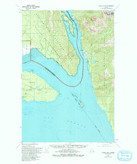
1950 Map of Juneau B-5
USGS Topo · Published 1968About this map
Glacier Bay National Monument dominates the northern reaches of this coastal landscape, where the wilderness meets the deep waters of Excursion Inlet. The map documents a period of specialized maritime activity centered at the Cannery and several small Cabin sites along the eastern shore. Navigation is vital in these channels, evidenced by the Icy Passage Light and Aero Light positioned to guide vessels through Icy Passage and Icy Strait.
Find a feature on this map
24 named features on this map. Tap any name to fly to it.
Don’t see what you’re looking for? This feature index may not catch every label — zoom into the map to look around manually.
Map Details
Editions of this 1950 Juneau B-5 Map
2 editions found
Other maps of this area

1948 · Juneau C-5
USGS Topo · 1:63,360

1948 · Juneau B-4
USGS Topo · 1:63,360

1948 · Juneau B-6
USGS Topo · 1:63,360

1948 · Juneau C-4
USGS Topo · 1:63,360

1948 · Juneau A-4
USGS Topo · 1:63,360

1948 · Juneau C-6
USGS Topo · 1:63,360

1948 · Juneau B-5
USGS Topo · 1:63,360

1949 · Juneau C-4
USGS Topo · 1:63,360

1949 · Juneau B-4
USGS Topo · 1:63,360

1950 · Juneau C-6
USGS Topo · 1:63,360