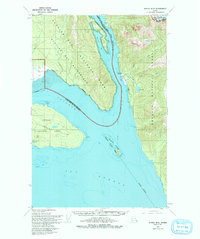
1950 Map of Juneau B-5
USGS Topo · Published 1993About this map
The maritime crossroads where Icy Strait meets Excursion Inlet defines this 1950 topographical study of the Alaskan coast. The map highlights the essential infrastructure of a water-bound economy, showing the Seaplane Anchorage and Icy Passage Light that guided vessels through the complex channels around Pleasant Island. Remnants of local industry and community are evident at the Cannery (Site) House and a nearby Cem, reflecting the seasonal and permanent settlements that once thrived along these shores. The landscape is split between the Glacier Bay National Wilderness Park to the west and the Tongass National Forest to the east, illustrating the vast protected wilderness during the mid-century era. Details such as Neva Lake and Sawmill Bay offer specific points of interest for researchers tracing the historical footprint of early Southeast Alaska resource extraction and navigation.
Find a feature on this map
24 named features on this map. Tap any name to fly to it.
Don’t see what you’re looking for? This feature index may not catch every label — zoom into the map to look around manually.
Map Details
Editions of this 1950 Juneau B-5 Map
2 editions found

Other maps of this area

1948 · Juneau C-5
USGS Topo · 1:63,360

1948 · Juneau B-4
USGS Topo · 1:63,360

1948 · Juneau B-6
USGS Topo · 1:63,360

1948 · Juneau C-4
USGS Topo · 1:63,360

1948 · Juneau A-4
USGS Topo · 1:63,360

1948 · Juneau C-6
USGS Topo · 1:63,360

1948 · Juneau B-5
USGS Topo · 1:63,360

1949 · Juneau C-4
USGS Topo · 1:63,360

1949 · Juneau B-4
USGS Topo · 1:63,360

1950 · Juneau C-6
USGS Topo · 1:63,360