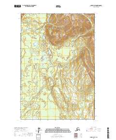
2017 Map of Juneau C-6 SE
USGS Topo · Published 2017About this map
Glacier Bay National Park encompasses the majority of this landscape, where a complex network of glacial meltwater channels defines the terrain. The Salmon River and Bartlett River flow through extensive wetlands and alluvial plains, illustrating the dynamic hydrology of the Hoonah-Angoon region. In the western portion of the map, the Beartrack River meanders toward the coast, while Bartlett Lake sits as a significant catchment in the southern reach. The absence of roads or permanent settlements highlights the preservation of this wilderness area under the management of the National Park Service, documenting the natural state of these drainage basins during the early twenty-first century.
Find a feature on this map
11 named features on this map. Tap any name to fly to it.
Don’t see what you’re looking for? This feature index may not catch every label — zoom into the map to look around manually.
Map Details
Editions of this 2017 Juneau C-6 SE Map
This is the sole edition of this map. No revisions or reprints were ever made.
Other maps of this area

1948 · Juneau C-5
USGS Topo · 1:63,360

1948 · Juneau B-6
USGS Topo · 1:63,360

1948 · Juneau C-6
USGS Topo · 1:63,360

1948 · Juneau B-5
USGS Topo · 1:63,360

1950 · Juneau C-6
USGS Topo · 1:63,360

1950 · Juneau B-5
USGS Topo · 1:63,360

1951 · Juneau
USGS Topo · 1:250,000

1962 · Juneau
USGS Topo · 1:250,000
2015 · Juneau B-5 NW
USGS Topo · 1:25,000
2015 · Juneau B-6 NE
USGS Topo · 1:25,000