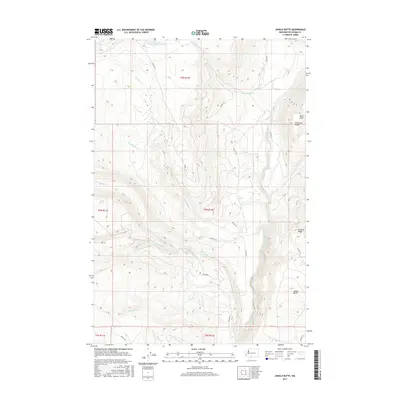
2017 Map of Jungle Butte
USGS Topo · Published 2017About this map
Mount Adams Lake sits in the northern reaches of this high-elevation terrain, where complex drainage patterns define the landscape of Yakima County. The Klickitat River flows through the eastern portion of the sheet, joined by tributaries such as Soda Spring Cr and Surveyors Cr. Significant elevation markers include Miller Point and the namesake Jungle Butte, which anchors the southeastern corner.
Find a feature on this map
31 named features on this map. Tap any name to fly to it.
Don’t see what you’re looking for? This feature index may not catch every label — zoom into the map to look around manually.
Map Details
Editions of this 2017 Jungle Butte Map
This is the sole edition of this map. No revisions or reprints were ever made.
Other maps of this area

1904 · Mount Adams
USGS Topo · 1:125,000

1907 · Mount Adams
USGS Topo · 1:125,000

1950 · Yakima
USGS Topo · 1:250,000

1958 · Yakima
USGS Topo · 1:250,000

1961 · Yakima
USGS Topo · 1:250,000
1969 · Castile Falls
USGS Topo · 1:24,000
1970 · Outlet Falls
USGS Topo · 1:24,000
1970 · Glenwood
USGS Topo · 1:24,000
1970 · Signal Peak
USGS Topo · 1:24,000
1970 · Castile Falls
USGS Topo · 1:24,000