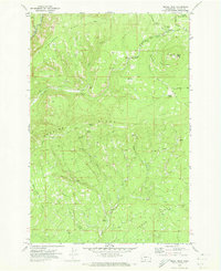
1970 Map of Signal Peak
USGS Topo · Published 1973About this map
The Klickitat River marks the northwestern corner of this territory within the boundary of the Yakima Indian Reservation, where the terrain rises sharply from the riverbanks toward the high points of Pinegrass Ridge and Peavine Ridge. Central to the activity on this landscape is Signal Peak, a strategic height featuring a Heliport, a Lookout Tower, and the nearby Signal Peak Ranger Station.
Find a feature on this map
29 named features on this map. Tap any name to fly to it.
Don’t see what you’re looking for? This feature index may not catch every label — zoom into the map to look around manually.
Map Details
Editions of this 1970 Signal Peak Map
This is the sole edition of this map. No revisions or reprints were ever made.
Other maps of this area

1904 · Mount Adams
USGS Topo · 1:125,000

1907 · Mount Adams
USGS Topo · 1:125,000

1950 · Yakima
USGS Topo · 1:250,000

1958 · Yakima
USGS Topo · 1:250,000

1961 · Yakima
USGS Topo · 1:250,000
1968 · Twin Buttes
USGS Topo · 1:24,000
1969 · Castile Falls
USGS Topo · 1:24,000
1970 · Outlet Falls
USGS Topo · 1:24,000
1970 · Lost Horse Plateau
USGS Topo · 1:24,000
1970 · Glenwood
USGS Topo · 1:24,000