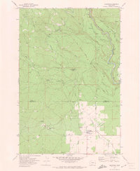
1970 Map of Glenwood
USGS Topo · Published 1973About this map
Glenwood serves as the primary settlement on this landscape, located entirely within the Yakima Indian Reservation. The area is defined by its complex boundary history, showing both the Old Indian Res Boundary (Campbell Line-1906) and the Old Indian Reservation Boundary (Perham Line 1920-22). These surveyed lines underscore the shifting legal geography of the region in the early twentieth century.
Find a feature on this map
33 named features on this map. Tap any name to fly to it.
Don’t see what you’re looking for? This feature index may not catch every label — zoom into the map to look around manually.
Map Details
Editions of this 1970 Glenwood Map
This is the sole edition of this map. No revisions or reprints were ever made.
Other maps of this area

1904 · Mount Adams
USGS Topo · 1:125,000

1907 · Mount Adams
USGS Topo · 1:125,000

1934 · The Dalles
USGS Topo · 1:125,000

1950 · Yakima
USGS Topo · 1:250,000

1953 · The Dalles
USGS Topo · 1:250,000

1956 · The Dalles
USGS Topo · 1:250,000

1957 · The Dalles
USGS Topo · 1:250,000

1957 · Klickitat
USGS Topo · 1:62,500

1957 · Husum
USGS Topo · 1:62,500

1958 · Yakima
USGS Topo · 1:250,000