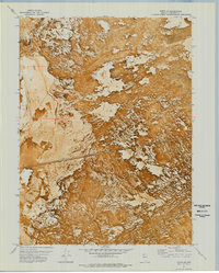
1971 Map of Jungo NE
USGS Topo · Published 1977About this map
The Western Pacific railroad cuts a straight, solitary line across this arid landscape in the early 1970s. This orthophotomap, which layers topographic data over a rectified aerial photograph, reveals the stark contrast between the bright, reflective surfaces of the Alkali Flats and the surrounding textured basins. The area is dominated by the broad expanse of Desert Flat, where the lack of permanent settlement emphasizes the scale of the Great Basin terrain. The grid of the Public Land Survey System, including lines for Township 35 and 36 North, provides the only human-imposed structure outside of the rail corridor. This specific mapping style allows researchers to see the actual vegetation patterns and alluvial fans as they existed during the 1971 field check, providing a visual depth that standard line maps often omit.
Find a feature on this map
5 named features on this map. Tap any name to fly to it.
Don’t see what you’re looking for? This feature index may not catch every label — zoom into the map to look around manually.
Map Details
Editions of this 1971 Jungo NE Map
This is the sole edition of this map. No revisions or reprints were ever made.
Other maps of this area

1886 · Disaster
USGS Topo · 1:250,000

1893 · Disaster
USGS Topo · 1:250,000

1931 · Lovelock
USGS Topo · 1:250,000

1935 · Lovelock
USGS Topo · 1:250,000

1939 · Eugene Mountains Area
USGS Topo · 1:62,500

1942 · Eugene Mountains Area
USGS Topo · 1:62,500

1954 · Vya
USGS Topo · 1:250,000

1955 · Lovelock
USGS Topo · 1:250,000

1958 · Vya
USGS Topo · 1:250,000

1959 · Lovelock
USGS Topo · 1:250,000