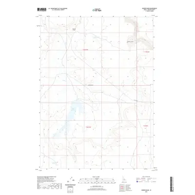
2020 Map of Juniper Basin
USGS Topo · Published 2020About this map
Owyhee River watercourses carve through the high desert of Owyhee County, defining the northeastern corner of this remote Idaho landscape. The terrain is marked by significant hydrological features including the Juniper Basin Reservoir and the expansive Juniper Basin, which collect drainage from intermittent streams like Juniper Cr. This area is characterized by its drainage infrastructure, shown through specific sites like Y P Reservoir Number 1 and Y P Reservoir Number 33, reflecting the region's managed water resources for ranching or land management. Steep elevation changes are most prominent at Hole Up Canyon and the deep Owyhee Canyon. The presence of State Line Rd running through the southeastern section indicates the proximity to the Nevada border, serving as one of the few established transportation routes through this sparsely populated territory.
Find a feature on this map
13 named features on this map. Tap any name to fly to it.
Don’t see what you’re looking for? This feature index may not catch every label — zoom into the map to look around manually.
Map Details
Editions of this 2020 Juniper Basin Map
This is the sole edition of this map. No revisions or reprints were ever made.
Other maps of this area

1955 · McDermitt
USGS Topo · 1:250,000

1955 · Jordan Valley
USGS Topo · 1:250,000

1957 · Jordan Valley
USGS Topo · 1:250,000

1958 · Jordan Valley
USGS Topo · 1:250,000

1959 · McDermitt
USGS Topo · 1:250,000

1964 · Hat Peak
USGS Topo · 1:62,500

1971 · Juniper Basin SE
USGS Topo · 1:24,000

1971 · Juniper Basin
USGS Topo · 1:24,000
1971 · Jarvis Pasture
USGS Topo · 1:24,000

1971 · Ross Lake
USGS Topo · 1:24,000