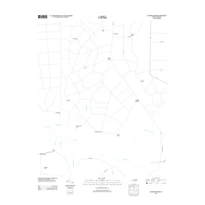
2013 Map of Juniper Creek
USGS Topo · Published 2013About this map
Clewis Corner and Big Curve anchor this low-lying landscape in Columbus County, where a network of ridge-and-swamp terrain defines the local geography. The map reveals an intricate hydrological system including Alligator Swamp, Second Cross Swamp, and First Cross Swamp, all feeding into the winding path of Juniper Creek. These wetlands are punctuated by higher ground such as Bee Tree Ridge, Schoolhouse Ridge, and Grays Ridge, which traditionally served as the primary sites for human activity and agriculture. Named clearances like Ward Field, Bennett Little Field, and Millpond Field illustrate the long-standing land use patterns in this coastal plain environment. The presence of Tram Road suggests the historical importance of timber or industrial transit through these bottomlands, connecting remote points like Hoy Savanna and The Opening to more established local routes.
Find a feature on this map
32 named features on this map. Tap any name to fly to it.
Don’t see what you’re looking for? This feature index may not catch every label — zoom into the map to look around manually.
Map Details
Editions of this 2013 Juniper Creek Map
This is the sole edition of this map. No revisions or reprints were ever made.
Other maps of this area

1942 · Juniper Creek
USGS Topo · 1:24,000

1943 · Freeland
USGS Topo · 1:24,000

1943 · Honey Island
USGS Topo · 1:24,000

1943 · Exum
USGS Topo · 1:24,000

1943 · Supply
USGS Topo · 1:24,000

1944 · Supply
USGS Topo · 1:31,680
1950 · Supply
USGS Topo · 1:25,000

1953 · Florence
USGS Topo · 1:250,000

1954 · Florence
USGS Topo · 1:250,000

1954 · Bolton
USGS Topo · 1:62,500