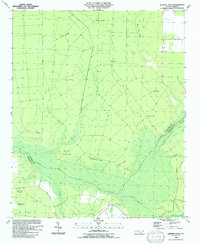
1990 Map of Juniper Creek
USGS Topo · Published 1991About this map
Green Swamp dominates the center of this 1990 survey, showing the complex hydrology of the coastal plains along the border of Columbus and Brunswick counties. The landscape is a mosaic of wet lowlands and slightly elevated ridges, such as Cox Ridge and Schoolhouse Ridge, which traditionally provided the dry ground necessary for small-scale agriculture and early settlement. Small clearings like Little Field and Ward Field are scattered throughout the dense drainage network of Juniper Creek and its many tributaries.
Find a feature on this map
36 named features on this map. Tap any name to fly to it.
Don’t see what you’re looking for? This feature index may not catch every label — zoom into the map to look around manually.
Map Details
Editions of this 1990 Juniper Creek Map
This is the sole edition of this map. No revisions or reprints were ever made.
Other maps of this area

1942 · Juniper Creek
USGS Topo · 1:24,000

1943 · Freeland
USGS Topo · 1:24,000

1943 · Honey Island
USGS Topo · 1:24,000

1943 · Exum
USGS Topo · 1:24,000

1943 · Supply
USGS Topo · 1:24,000

1944 · Supply
USGS Topo · 1:31,680
1950 · Supply
USGS Topo · 1:25,000

1953 · Florence
USGS Topo · 1:250,000

1954 · Florence
USGS Topo · 1:250,000

1954 · Bolton
USGS Topo · 1:62,500