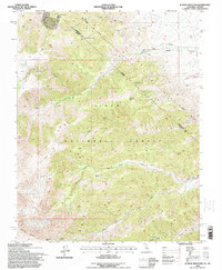
1994 Map of Juniper Mountain
USGS Topo · Published 1998About this map
Inyo National Forest dominates this high-altitude landscape along the border of California and Nevada, where the jagged peaks of the White Mts rise above deep canyons. The map documents an area defined by historical boundary surveys and resource extraction, notably featuring the Von Schmidt Line (1873) which traces an earlier frontier through the mountains. Mining interest is evident in the northwestern corner with the Evergreen Mine, the Green Monster Mine, and various Prospects scattered near the springs. The terrain transitions from the high summits of Juniper Mountain and Pinyon Mountain down to the alluvial spreads of Cabin Flats and Perry Aiken Flat. A complex drainage system including Leidy Creek, Chiatovich Creek, and McAfee Creek channels snowmelt away from the peaks, supported by numerous unnamed Springs that provided vital water for early travelers and miners in this arid environment.
Find a feature on this map
26 named features on this map. Tap any name to fly to it.
Don’t see what you’re looking for? This feature index may not catch every label — zoom into the map to look around manually.
Map Details
Editions of this 1994 Juniper Mountain Map
This is the sole edition of this map. No revisions or reprints were ever made.
Other maps of this area

1917 · White Mountain
USGS Topo · 1:125,000

1947 · Mariposa
USGS Topo · 1:250,000

1948 · Mariposa
USGS Topo · 1:250,000

1957 · Mariposa
USGS Topo · 1:250,000

1962 · Benton
USGS Topo · 1:62,500

1962 · Mt. Barcroft
USGS Topo · 1:62,500

1962 · White Mtn. Peak
USGS Topo · 1:62,500

1963 · Mariposa
USGS Topo · 1:250,000

1963 · Davis Mountain
USGS Topo · 1:62,500
1987 · East of Davis Mtn.
USGS Topo · 1:24,000