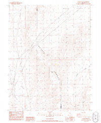
1986 Map of Juniper Peak
USGS Topo · Published 1986About this map
Truckee Range peaks dominate this mid-1980s landscape at the boundary of Washoe and Churchill Counties. The high desert terrain is defined by the elevation of Juniper Peak and the surrounding drainage basins of North Valley and Little Valley. This provisional study records the infrastructure of the late twentieth-century West, tracing several Transmission Lines and a Pipeline that cut across the topography to serve regional energy needs. While lacking permanent settlements, the presence of a Water Well in the western valley and numerous 4wd tracks suggests intermittent utility maintenance and ranching activity. The map provides a precise record of the physical relief before modern geospatial shifts, documenting named geological features such as Tolbert Canyon and Miry Place Canyon which drain the eastern slopes of the range.
Find a feature on this map
11 named features on this map. Tap any name to fly to it.
Don’t see what you’re looking for? This feature index may not catch every label — zoom into the map to look around manually.
Map Details
Editions of this 1986 Juniper Peak Map
This is the sole edition of this map. No revisions or reprints were ever made.
Other maps of this area

1890 · Wadsworth
USGS Topo · 1:125,000

1892 · Wadsworth
USGS Topo · 1:125,000

1894 · Wadsworth
USGS Topo · 1:125,000

1957 · Fireball Ridge
USGS Topo · 1:62,500

1957 · Two Tips
USGS Topo · 1:62,500

1957 · Wadsworth
USGS Topo · 1:62,500

1957 · Nixon
USGS Topo · 1:62,500

1957 · Reno
USGS Topo · 1:250,000

1959 · Reno
USGS Topo · 1:250,000

1960 · Reno
USGS Topo · 1:250,000