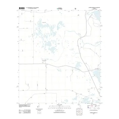
2012 Map of Juniper Springs
USGS Topo · Published 2012About this map
Juniper Prairie dominates this landscape, revealing a mosaic of wetlands and isolated islands within the Ocala National Forest region. The map documents a hydrologically significant area where major artesian sources like Juniper Springs, Fern Hammock Springs, and Sweetwater Springs feed a network of creeks. To the northeast, the shoreline of Lake George appears, intersected by Silver Glen Springs and Juniper Hunt Club Rd. This 2012 survey illustrates the balance between recreation and preservation, featuring the Juniper Springs Campground alongside remote landmarks like Pats Island and the Wildcat Lake Boat Ramp. For local historians and genealogists, the inclusion of Long Cem near the northern border provides a specific point of reference for early settlers in this unique terrain.
Find a feature on this map
22 named features on this map. Tap any name to fly to it.
Don’t see what you’re looking for? This feature index may not catch every label — zoom into the map to look around manually.
Map Details
Editions of this 2012 Juniper Springs Map
This is the sole edition of this map. No revisions or reprints were ever made.
Other maps of this area

1954 · Daytona Beach
USGS Topo · 1:250,000

1958 · Daytona Beach
USGS Topo · 1:250,000

1964 · Daytona Beach
USGS Topo · 1:250,000

1970 · Welaka SE
USGS Topo · 1:24,000

1970 · Salt Springs
USGS Topo · 1:24,000

1970 · Halfmoon Lake
USGS Topo · 1:24,000
1970 · Lake Kerr
USGS Topo · 1:24,000

1972 · Juniper Springs
USGS Topo · 1:24,000
1972 · Farles Lake
USGS Topo · 1:24,000
1972 · Astor
USGS Topo · 1:24,000