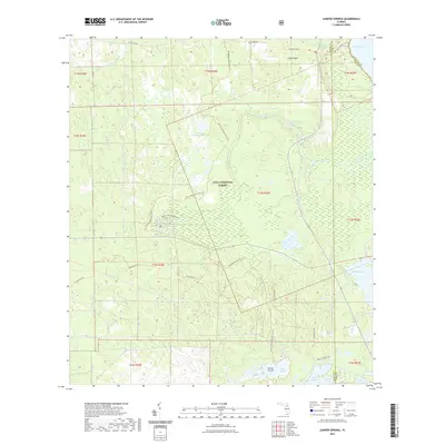
2021 Map of Juniper Springs
USGS Topo · Published 2021About this map
Ocala National Forest dominates this landscape, where the sandy floor of the Florida peninsula gives rise to a remarkable cluster of artesian springs. The hydrology of the region is centered on the Juniper Springs recreation area, where Fern Hammock Springs and several smaller vents feed the headwaters of Juniper Creek. This waterway meanders eastward toward Lake George, passing through the broad, open expanse of Juniper Prairie. To the north, the terrain transitions toward Pats Island, while the western portion is marked by Crooked Sapling Pond. This modern survey records an extensive network of recreational and historical paths, including the Florida National Scenic Trl, The Yearling Trl, and the Centennial Trl. The map also captures the remote character of the interior wetlands, tracing features from Wildcat Lake to the southern reaches of Farles Prairie and Sellers Lake.
Find a feature on this map
32 named features on this map. Tap any name to fly to it.
Don’t see what you’re looking for? This feature index may not catch every label — zoom into the map to look around manually.
Map Details
Editions of this 2021 Juniper Springs Map
This is the sole edition of this map. No revisions or reprints were ever made.
Other maps of this area

1954 · Daytona Beach
USGS Topo · 1:250,000

1958 · Daytona Beach
USGS Topo · 1:250,000

1964 · Daytona Beach
USGS Topo · 1:250,000

1970 · Welaka SE
USGS Topo · 1:24,000

1970 · Salt Springs
USGS Topo · 1:24,000

1970 · Halfmoon Lake
USGS Topo · 1:24,000
1970 · Lake Kerr
USGS Topo · 1:24,000

1972 · Juniper Springs
USGS Topo · 1:24,000
1972 · Farles Lake
USGS Topo · 1:24,000
1972 · Astor
USGS Topo · 1:24,000