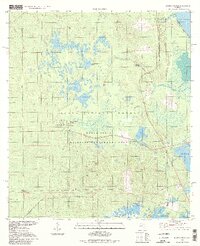
1994 Map of Juniper Springs
USGS Topo · Published 1998About this map
Juniper Springs and Fern Hammock Springs anchor this portion of the Ocala National Forest, where spring-fed waters emerge to form the headwaters of Juniper Creek. The landscape is defined by the high water tables of the Florida peninsula, featuring the broad expanse of Juniper Prairie and several large water bodies including Wildcat Lake and the western shore of Lake George. The interior is marked by the presence of the Ocala State Wildlife Management Area and the U S Naval Reservation, showing a region largely dedicated to conservation and government use rather than residential development. This 1994 photo-inspection of 1969 imagery captures the network of light-duty and unimproved roads that navigate between distinctive wetlands like Farles Prairie and Morman Branch.
Find a feature on this map
28 named features on this map. Tap any name to fly to it.
Don’t see what you’re looking for? This feature index may not catch every label — zoom into the map to look around manually.
Map Details
Editions of this 1994 Juniper Springs Map
This is the sole edition of this map. No revisions or reprints were ever made.
Other maps of this area

1954 · Daytona Beach
USGS Topo · 1:250,000

1958 · Daytona Beach
USGS Topo · 1:250,000

1964 · Daytona Beach
USGS Topo · 1:250,000

1970 · Welaka SE
USGS Topo · 1:24,000

1970 · Salt Springs
USGS Topo · 1:24,000

1970 · Halfmoon Lake
USGS Topo · 1:24,000
1970 · Lake Kerr
USGS Topo · 1:24,000

1972 · Juniper Springs
USGS Topo · 1:24,000
1972 · Farles Lake
USGS Topo · 1:24,000
1972 · Astor
USGS Topo · 1:24,000