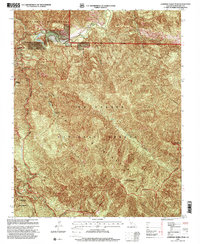
1995 Map of Junipero Serra Peak
USGS Topo · Published 2000About this map
Junipero Serra Peak dominates this high-altitude landscape in the mid-1990s, serving as a primary landmark within the massive Los Padres National Forest. The map documents a rugged interior network of water and trails, including the winding Arroyo Seco and the secluded The Lakes to the northwest. Significant human presence is noted at the Arroyo Seco Station and Last Chance Camp, which provide access points for the Santa Lucia Trail as it traverses the Ventana Wilderness.
Find a feature on this map
16 named features on this map. Tap any name to fly to it.
Don’t see what you’re looking for? This feature index may not catch every label — zoom into the map to look around manually.
Map Details
Editions of this 1995 Junipero Serra Peak Map
This is the sole edition of this map. No revisions or reprints were ever made.
Other maps of this area

1915 · Soledad
USGS Topo · 1:62,500

1919 · Junipero Serra
USGS Topo · 1:62,500

1920 · Jamesburg
USGS Topo · 1:48,000

1921 · Jamesburg
USGS Topo · 1:62,500

1921 · Lucia
USGS Topo · 1:62,500

1939 · Jamesburg
USGS Topo · 1:62,500

1940 · Jamesburg
USGS Topo · 1:62,500

1940 · Soledad
USGS Topo · 1:62,500

1941 · Lucia
USGS Topo · 1:62,500

1941 · Junipero Serra
USGS Topo · 1:62,500