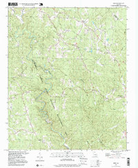
1997 Map of Juno
USGS Topo · Published 1999About this map
Amicalola Dawson Forest State Wildlife Management Area dominates the western half of this North Georgia terrain, where the winding course of Amicalola Creek cuts through the landscape. The map captures a transition from protected woodland to established rural communities, centered around the settlement of Juno and the county seat at Dawsonville. This era reveals a network of small country churches and schools that served the surrounding hills, including McKees Chapel, Pleasant Grove Ch, and the West Side Sch.
Find a feature on this map
25 named features on this map. Tap any name to fly to it.
Don’t see what you’re looking for? This feature index may not catch every label — zoom into the map to look around manually.
Map Details
Editions of this 1997 Juno Map
This is the sole edition of this map. No revisions or reprints were ever made.
Other maps of this area

1888 · Ellijay
USGS Topo · 1:125,000

1890 · Suwanee
USGS Topo · 1:125,000

1892 · Ellijay
USGS Topo · 1:125,000

1894 · Suwanee
USGS Topo · 1:125,000

1898 · Ellijay
USGS Topo · 1:125,000

1911 · Ellijay
USGS Topo · 1:125,000

1926 · Tate
USGS Topo · 1:62,500

1928 · Tate
USGS Topo · 1:62,500
1950 · Campbell Mtn
USGS Topo · 1:24,000

1955 · Rome
USGS Topo · 1:250,000