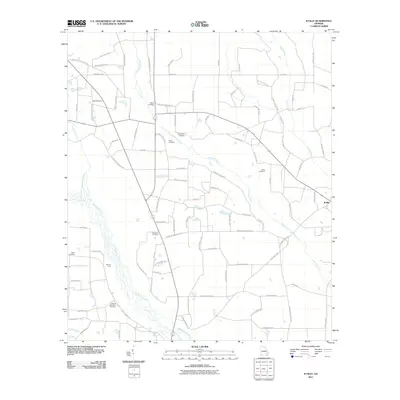
2011 Map of K'Ville
USGS Topo · Published 2011About this map
Big Satilla Creek defines the southwestern landscape of this Wayne County quadrangle, where the braided waters of the river system meet a network of rural homesteads and family burial grounds. The settlement of K'Ville sits at the eastern edge of the survey, connected to the surrounding countryside by roads like Antioch Church Rd and Piney Grove Church Rd. This 2011 record is particularly valuable for genealogists, as it documents numerous family and memorial sites including Paulk Cemetery, Williamson Cemetery, Dixon Cemetery, and the Martha Memorial Cemetery. Terrain features such as Moody Ford indicate historical crossing points along the creek, while several named drainage systems like Sweetwater Creek and Colemans Creek illustrate the low-lying coastal plain topography. The naming of nearly every minor road after local families further highlights the established community structure of the era.
Find a feature on this map
101 named features on this map. Tap any name to fly to it.
Don’t see what you’re looking for? This feature index may not catch every label — zoom into the map to look around manually.
Map Details
Editions of this 2011 K'Ville Map
This is the sole edition of this map. No revisions or reprints were ever made.
Other maps of this area

1953 · Waycross
USGS Topo · 1:250,000

1958 · Waycross
USGS Topo · 1:250,000
1971 · Odum
USGS Topo · 1:24,000

1971 · Surrency
USGS Topo · 1:24,000
1971 · Ritch
USGS Topo · 1:24,000

1971 · Coffee
USGS Topo · 1:24,000

1971 · K'ville
USGS Topo · 1:24,000

1971 · Patterson
USGS Topo · 1:24,000
1971 · Screven
USGS Topo · 1:24,000

1971 · Mershon
USGS Topo · 1:24,000