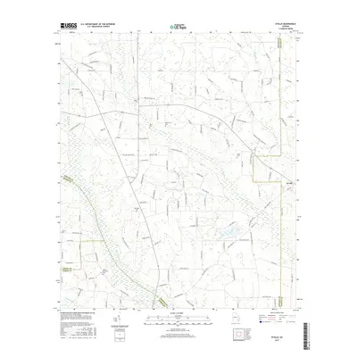
2017 Map of K'Ville
USGS Topo · Published 2017About this map
Big Satilla Cr and its winding tributaries define the landscape of this Southeast Georgia territory at the intersection of Appling, Wayne, Bacon, and Pierce counties. The settlement of K'Ville sits at the eastern edge, serving as a focal point for a rural network of family-named roads and homesteads. The map is a significant resource for genealogists, documenting numerous local burial grounds including Patterson Cem, Martha Memorial Cem, and Paulk Cem, which are scattered throughout the pine-staked lowlands. Small creek systems like Colemans Cr, Sweetwater Cr, and Reedy Cr weave between the grids of Pratt Hutto Rd and Tower Rd, illustrating the persistent drainage patterns of the coastal plain. The presence of multiple family-named markers like Gerald Hersey and Bryant Boyette suggests a community where heritage remains deeply tied to specific tracts of land.
Find a feature on this map
124 named features on this map. Tap any name to fly to it.
Don’t see what you’re looking for? This feature index may not catch every label — zoom into the map to look around manually.
Map Details
Editions of this 2017 K'Ville Map
This is the sole edition of this map. No revisions or reprints were ever made.
Other maps of this area

1953 · Waycross
USGS Topo · 1:250,000

1958 · Waycross
USGS Topo · 1:250,000
1971 · Odum
USGS Topo · 1:24,000

1971 · Surrency
USGS Topo · 1:24,000
1971 · Ritch
USGS Topo · 1:24,000

1971 · Coffee
USGS Topo · 1:24,000

1971 · K'ville
USGS Topo · 1:24,000

1971 · Patterson
USGS Topo · 1:24,000
1971 · Screven
USGS Topo · 1:24,000

1971 · Mershon
USGS Topo · 1:24,000