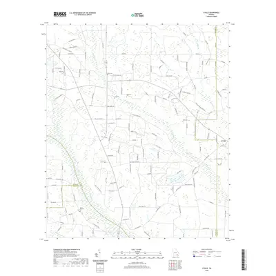
2020 Map of K'Ville
USGS Topo · Published 2020About this map
Colemans Cr and the Big Satilla Cr define the low-lying hydrology of this Georgia landscape where the borders of Wayne, Appling, Pierce, and Bacon Counties meet. The rural settlement of K'Ville sits at the eastern edge, connected by a network of family-named roads such as Pratt Hutto Rd and Buddy Morris Rd. This 2020 record of the area preserves a high concentration of family and community burial sites, including the uniquely named Jesus Cem, as well as Patterson Cem, Millikin Cem, and Martha Memorial Cem. The scattered residential clusters of Gallberry and Gerald Hersey reflect the enduring decentralized agricultural character of the region. Local religious life is centered around landmarks like Zion Church of God, while the flat terrain is periodically marked by infrastructure like the Tower near Tower Rd.
Find a feature on this map
131 named features on this map. Tap any name to fly to it.
Don’t see what you’re looking for? This feature index may not catch every label — zoom into the map to look around manually.
Map Details
Editions of this 2020 K'Ville Map
This is the sole edition of this map. No revisions or reprints were ever made.
Other maps of this area

1953 · Waycross
USGS Topo · 1:250,000

1958 · Waycross
USGS Topo · 1:250,000
1971 · Odum
USGS Topo · 1:24,000

1971 · Surrency
USGS Topo · 1:24,000
1971 · Ritch
USGS Topo · 1:24,000

1971 · Coffee
USGS Topo · 1:24,000

1971 · K'ville
USGS Topo · 1:24,000

1971 · Patterson
USGS Topo · 1:24,000
1971 · Screven
USGS Topo · 1:24,000

1971 · Mershon
USGS Topo · 1:24,000