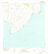
1962 Map of Ka Lae
USGS Topo · Published 1976About this map
Ka Lae, the southernmost point of the Big Island, is documented here during a period of transition between ancient cultural heritage and Cold War era technical installations. The coastline is dotted with traditional sacred sites such as Heiau o Kalalea and Heiau o Molilele, existing alongside modern infrastructure including an Astronomic Station and the Pacific Missile Range Facility. The landscape transitions from the volcanic terrain of the Lava Flow of 1868 to the agricultural holdings of Kahuku Ranch and the residential allotments at Kamaoa Homesteads. Geographic landmarks like the Lua o Palahemo water hole and the green sands of Mahana Bay reflect the unique geology of the Kaʻū District. Numerous trails and rock walls crisscross the interior, marking boundaries and routes between coastal points like Kamilo Point and the high ground at Puu Huluhulu.
Find a feature on this map
91 named features on this map. Tap any name to fly to it.
Don’t see what you’re looking for? This feature index may not catch every label — zoom into the map to look around manually.
Map Details
Editions of this 1962 Ka Lae Map
2 editions found
Other maps of this area

1924 · Kalae
USGS Topo · 1:62,500

1924 · Honuapo
USGS Topo · 1:62,500

1954 · Hawaii South
USGS Topo · 1:250,000

1959 · Hawaii South
USGS Topo · 1:250,000

1961 · Hawaii South
USGS Topo · 1:250,000

1962 · Hawaii South
USGS Topo · 1:250,000

1962 · Puu Hou
USGS Topo · 1:24,000

1962 · Kahuku Ranch
USGS Topo · 1:24,000
1962 · Ka Lae
USGS Topo · 1:24,000
1962 · Naalehu
USGS Topo · 1:24,000