
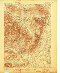
1899 Map of Kaaterskill
USGS Topo · Published 1899About this map
Ulster and Delaware R.R. tracks and the specialized Otis Elevating Ry. define the rugged transportation corridor of this 1890s survey. The map details the Catskills at a peak moment of resort culture and industrial access, marked by the iconic Mountain House and exclusive enclaves like Onteora Park and Twilight Park. Deep ravines such as Santa Cruz Ravine and Wildcat Ravine punctuate the steep descents toward the Hudson Valley, while settlements like Kaaterskill Junction served as critical nodes for narrow gauge rail operations.
Find a feature on this map
93 named features on this map. Tap any name to fly to it.
Don’t see what you’re looking for? This feature index may not catch every label — zoom into the map to look around manually.
Map Details
Editions of this 1899 Kaaterskill Map
2 editions found
Other maps of this area

1892 · Kaaterskill
USGS Topo · 1:62,500

1893 · Kaaterskill
USGS Topo · 1:62,500

1893 · Coxsackie
USGS Topo · 1:62,500

1893 · Durham
USGS Topo · 1:62,500

1894 · Coxsackie
USGS Topo · 1:62,500

1894 · Kaaterskill
USGS Topo · 1:62,500

1894 · Durham
USGS Topo · 1:62,500

1895 · Catskill
USGS Topo · 1:62,500

1898 · Rhinebeck
USGS Topo · 1:62,500

1900 · Phoenicia
USGS Topo · 1:62,500