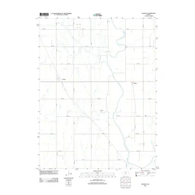
2012 Map of Kackley
USGS Topo · Published 2012About this map
Republican River meanders through this portion of Republic County, defining a landscape shaped by water and a rigid grid of rural roads. The small unincorporated settlements of Kackley and Norway serve as local anchors in an area dominated by agriculture and sprawling creek systems. The hydrology is particularly dense here, with Beaver Cr, Oak Cr, and Skunk Cr carving through the prairie to meet the river. Local history and genealogy are preserved at the Oakdale Cem and Valley Cem, while remnants of early travel routes like Wagon Rd intersect with modern thoroughfares such as State Highway 148. This survey captures the enduring rural character of North Central Kansas, where the intersection of water bodies and section lines has dictated land use for generations.
Find a feature on this map
34 named features on this map. Tap any name to fly to it.
Don’t see what you’re looking for? This feature index may not catch every label — zoom into the map to look around manually.
Map Details
Editions of this 2012 Kackley Map
This is the sole edition of this map. No revisions or reprints were ever made.
Other maps of this area

1892 · Concordia
USGS Topo · 1:125,000

1955 · Manhattan
USGS Topo · 1:250,000

1956 · Manhattan
USGS Topo · 1:250,000

1957 · Manhattan
USGS Topo · 1:250,000

1965 · Concordia NW
USGS Topo · 1:24,000
1965 · Concordia
USGS Topo · 1:24,000

1965 · Kackley
USGS Topo · 1:24,000

1966 · Scandia
USGS Topo · 1:24,000
1966 · Scottsville
USGS Topo · 1:24,000
1966 · Jamestown
USGS Topo · 1:24,000