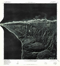
1977 Map of Kaena
USGS Topo · Published 1984About this map
Kaena Point marks the westernmost tip of Oahu in this late-1970s orthophotograph, where the land meets the massive expanse of the Pacific Ocean. This specialized aerial survey provides a photographic record of the coast and interior ridges, revealing the sharp geographical transition from the coastal plains at Mokuleia to the steep, erosion-carved walls of Makua Valley. The imagery captures the distinct land use patterns of the era, from the established airfield and agricultural plots along the northern shore to the undeveloped coastal stretch near Ohiki-Lolo. Unlike traditional topographic maps, this orthophoto uses rectified imagery taken in 1977 to document the exact vegetation, road paths, and shoreline conditions of the North Shore before later development and conservation efforts altered the landscape.
Find a feature on this map
5 named features on this map. Tap any name to fly to it.
Don’t see what you’re looking for? This feature index may not catch every label — zoom into the map to look around manually.
Map Details
Editions of this 1977 Kaena Map
This is the sole edition of this map. No revisions or reprints were ever made.
Other maps of this area

1952 · Waimea
USGS Topo · 1:24,000

1953 · Haleiwa
USGS Topo · 1:24,000

1953 · Schofield Barracks
USGS Topo · 1:24,000

1954 · Oahu
USGS Topo · 1:250,000

1954 · Waianae
USGS Topo · 1:24,000

1954 · Kaena
USGS Topo · 1:24,000

1960 · Haleiwa
USGS Topo · 1:24,000

1960 · Schofield Barracks
USGS Topo · 1:24,000

1961 · Oahu
USGS Topo · 1:250,000
1963 · Waianae
USGS Topo · 1:24,000