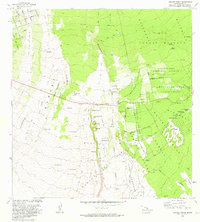
1981 Map of Kahuku Ranch
USGS Topo · Published 1981About this map
The volcanic activity of the Ka'u District defines this portion of Hawaii, where successive historical eruptions have carved the landscape into a complex of lava fields and islands of vegetation. Large-scale events such as the Lava Flow of 1907, the Lava Flow of 1887, and the Lava Flow of 1868 are meticulously delineated, showing how these flows bypassed certain areas to create kipukas like Kipuka Kahulihonua and Kipuka Mamane.
Find a feature on this map
83 named features on this map. Tap any name to fly to it.
Don’t see what you’re looking for? This feature index may not catch every label — zoom into the map to look around manually.
Map Details
Editions of this 1981 Kahuku Ranch Map
This is the sole edition of this map. No revisions or reprints were ever made.
Other maps of this area

1924 · Kalae
USGS Topo · 1:62,500

1924 · Honuapo
USGS Topo · 1:62,500

1928 · Hoopuloa
USGS Topo · 1:62,500

1954 · Hawaii South
USGS Topo · 1:250,000

1959 · Hawaii South
USGS Topo · 1:250,000

1961 · Hawaii South
USGS Topo · 1:250,000

1962 · Hawaii South
USGS Topo · 1:250,000

1962 · Puu Hou
USGS Topo · 1:24,000

1962 · Kahuku Ranch
USGS Topo · 1:24,000

1962 · Pohue Bay
USGS Topo · 1:24,000