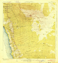
1928 Map of Kailua
USGS Topo · Published 1928About this map
The coastal village of Kailua serves as the focal point for this survey of the Kona coast, a landscape defined by volcanic geology and agricultural homesteads. Inland, the terrain rises sharply toward the peak of Puu Hualalei, passing through extensive land divisions like the Honuaula Forest Reserve and the Kahaluu Forest Reserve. The map illustrates a complex system of homesteads, including Kalaoa 1 Homesteads and Kohanaike Homesteads, which reflect the territory's early 20th-century land management under Governor Wallace R. Farrington. Industrial footprints are visible at the Kona Mill and Sisal Mill, while the cultural landscape is marked by the Kuamoo Church and the ancient Ahu a umi Heiau. Transportation routes like Judd Road navigate the lava fields, connecting scattered settlements and remote sites such as the Sheep Station and Puu Lehua Ranch.
Find a feature on this map
106 named features on this map. Tap any name to fly to it.
Don’t see what you’re looking for? This feature index may not catch every label — zoom into the map to look around manually.
Map Details
Editions of this 1928 Kailua Map
3 editions found
Other maps of this area

1927 · Kaohe
USGS Topo · 1:62,500

1928 · Puako
USGS Topo · 1:62,500

1928 · Kailua
USGS Topo · 1:62,500

1928 · Mauna Loa
USGS Topo · 1:62,500

1930 · Kaohe
USGS Topo · 1:62,500

1954 · Hawaii South
USGS Topo · 1:250,000

1954 · Hawaii North
USGS Topo · 1:250,000

1956 · Keamuku
USGS Topo · 1:24,000

1956 · Puu O Uo
USGS Topo · 1:24,000

1956 · Naohueleelua
USGS Topo · 1:24,000