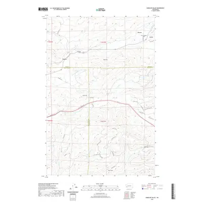
2020 Map of Kamilche Valley
USGS Topo · Published 2020About this map
Stimson and the Kamilche Valley occupy a landscape defined by the intersection of three Washington counties and the expansive timberlands of the Capitol Forest. This 2020 survey illustrates a region where local agriculture and small settlements like Marmac and Forbes meet the complex drainage systems of the Black Hills. Waterways such as Skookum Cr and the Mox Chehalis Cr carve through the terrain, while landmarks like Kennedy Falls and Hicklin Hill provide vertical relief. The map reveals an extensive network of forestry and utility roads, including Powerline Rd NW and Rock Candy Mountain Rd SW, which navigate the high points of Buck Ridge and the passage at Porter Pass. The convergence of Mason, Grays Harbor, and Thurston counties creates a jurisdictional puzzle atop this primarily forested and creek-fed environment.
Find a feature on this map
49 named features on this map. Tap any name to fly to it.
Don’t see what you’re looking for? This feature index may not catch every label — zoom into the map to look around manually.
Map Details
Editions of this 2020 Kamilche Valley Map
This is the sole edition of this map. No revisions or reprints were ever made.
Other maps of this area

1939 · Shelton
USGS Topo · 1:62,500

1941 · Gate
USGS Topo · 1:62,500

1941 · Ford
USGS Topo · 1:62,500

1943 · Nahwatzel Lake
USGS Topo · 1:62,500

1953 · Hoquiam
USGS Topo · 1:250,000

1953 · Rochester
USGS Topo · 1:62,500

1953 · Malone
USGS Topo · 1:62,500

1953 · Shelton
USGS Topo · 1:62,500

1953 · Elma
USGS Topo · 1:62,500

1957 · Hoquiam
USGS Topo · 1:250,000