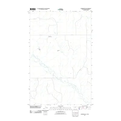
2011 Map of Kaminski Hill
USGS Topo · Published 2011About this map
Kaminski Hill stands as the central geographic anchor of this high-plains landscape in Valley County, Montana, situated near the Canadian border. The area is defined by its drainage systems, most notably the winding course of the West Fork Poplar River and its tributaries like Roanwood Creek and Coal Creek. Human presence in this vast section of the Missouri Plateau is signaled by the North Bench Community Hall, a focal point for the rural agricultural community that relies on the thin network of section-line roads. The infrastructure of the early 21st century is geared toward water management and cattle ranching, evidenced by features such as the Ghost Number 1 Dam and Kaminski Spring. Long, straight thoroughfares like N Bench Rd and Fossum Rd underscore the systematic grid of the Great Plains survey.
Find a feature on this map
12 named features on this map. Tap any name to fly to it.
Don’t see what you’re looking for? This feature index may not catch every label — zoom into the map to look around manually.
Map Details
Editions of this 2011 Kaminski Hill Map
This is the sole edition of this map. No revisions or reprints were ever made.
Other maps of this area

1954 · Glasgow
USGS Topo · 1:250,000

1957 · Glasgow
USGS Topo · 1:250,000

1958 · Glasgow
USGS Topo · 1:250,000

1973 · Glentana West
USGS Topo · 1:24,000

1973 · Brockway Spring
USGS Topo · 1:24,000

1973 · Richland
USGS Topo · 1:24,000

1973 · Kaminski Hill
USGS Topo · 1:24,000
1973 · Glentana East
USGS Topo · 1:24,000
1973 · Glass Hill
USGS Topo · 1:24,000

1984 · Opheim
USGS Topo · 1:100,000