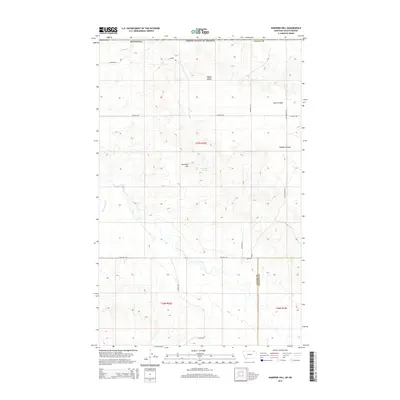
2014 Map of Kaminski Hill
USGS Topo · Published 2014About this map
Kaminski Hill and its namesake Kaminski Spring anchor this high plains landscape on the border of Valley and Daniels counties. The terrain is defined by dramatic erosional features typical of northeastern Montana, including Swift Coulee and Morgan Coulee, which cut through the drainage basins of Coal Cr and Roanwood Cr. The settlement pattern follows a rigid section-line grid established by the Public Land Survey System, with local transportation provided by a network of rural routes such as Bailey Rd, Jim Fossum Rd, and Fisher Rd. This 2014 survey shows the area of Happy Valley as a quiet ranching or agricultural region, where the vastness of the geography is punctuated by small, named landmarks and isolated water sources essential for livestock and land management.
Find a feature on this map
21 named features on this map. Tap any name to fly to it.
Don’t see what you’re looking for? This feature index may not catch every label — zoom into the map to look around manually.
Map Details
Editions of this 2014 Kaminski Hill Map
This is the sole edition of this map. No revisions or reprints were ever made.
Other maps of this area

1954 · Glasgow
USGS Topo · 1:250,000

1957 · Glasgow
USGS Topo · 1:250,000

1958 · Glasgow
USGS Topo · 1:250,000

1973 · Glentana West
USGS Topo · 1:24,000

1973 · Brockway Spring
USGS Topo · 1:24,000

1973 · Richland
USGS Topo · 1:24,000

1973 · Kaminski Hill
USGS Topo · 1:24,000
1973 · Glentana East
USGS Topo · 1:24,000
1973 · Glass Hill
USGS Topo · 1:24,000

1984 · Opheim
USGS Topo · 1:100,000