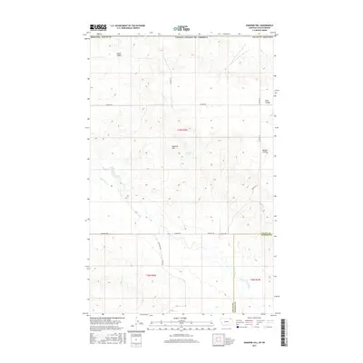
2017 Map of Kaminski Hill
USGS Topo · Published 2017About this map
Kaminski Hill stands as the central landmark in this portion of northeastern Montana, where the terrain is defined by the complex drainage systems of the W Fork Poplar River. This 2017 survey details a landscape of coulees and creeks that carve through the high plains along the Valley and Daniels County line. The area is characterized by large-scale agricultural and ranching divisions, marked by a network of section-line roads such as N Bench Rd and Glentanna Rd.
Find a feature on this map
22 named features on this map. Tap any name to fly to it.
Don’t see what you’re looking for? This feature index may not catch every label — zoom into the map to look around manually.
Map Details
Editions of this 2017 Kaminski Hill Map
This is the sole edition of this map. No revisions or reprints were ever made.
Other maps of this area

1954 · Glasgow
USGS Topo · 1:250,000

1957 · Glasgow
USGS Topo · 1:250,000

1958 · Glasgow
USGS Topo · 1:250,000

1973 · Glentana West
USGS Topo · 1:24,000

1973 · Brockway Spring
USGS Topo · 1:24,000

1973 · Richland
USGS Topo · 1:24,000

1973 · Kaminski Hill
USGS Topo · 1:24,000
1973 · Glentana East
USGS Topo · 1:24,000
1973 · Glass Hill
USGS Topo · 1:24,000

1984 · Opheim
USGS Topo · 1:100,000