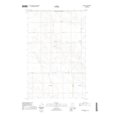
2020 Map of Kaminski Hill
USGS Topo · Published 2020About this map
Kaminski Hill stands as the central landmark of this high plains landscape in northeastern Montana, straddling the border between Valley Co and Daniels Co. This 2020 survey reveals a rural area defined by vast drainage patterns and a sparse network of section-line roads and named trails. The presence of Kaminski Spring provides a vital water source near the hill's summit, feeding into the surrounding coulees and creek beds that shape the terrain.
Find a feature on this map
19 named features on this map. Tap any name to fly to it.
Don’t see what you’re looking for? This feature index may not catch every label — zoom into the map to look around manually.
Map Details
Editions of this 2020 Kaminski Hill Map
This is the sole edition of this map. No revisions or reprints were ever made.
Other maps of this area

1954 · Glasgow
USGS Topo · 1:250,000

1957 · Glasgow
USGS Topo · 1:250,000

1958 · Glasgow
USGS Topo · 1:250,000

1973 · Glentana West
USGS Topo · 1:24,000

1973 · Brockway Spring
USGS Topo · 1:24,000

1973 · Richland
USGS Topo · 1:24,000

1973 · Kaminski Hill
USGS Topo · 1:24,000
1973 · Glentana East
USGS Topo · 1:24,000
1973 · Glass Hill
USGS Topo · 1:24,000

1984 · Opheim
USGS Topo · 1:100,000