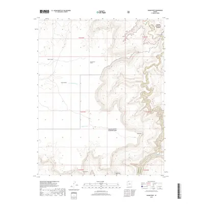
2018 Map of Kanab Point
USGS Topo · Published 2018About this map
Kanab Point overlooks the dramatic intersection of desert canyons and the high plateaus of northern Arizona. This 2018 survey details the complex vertical geography where the Kanab Plateau drops into the deep drainages of Kanab Cr and Chamberlain Canyon. Along the southern boundary, the Colorado River passes through Grand Canyon National Park, featuring the turbulent Kanab Rapid. The map serves as a record of vital water sources in this arid landscape, noting the locations of North Spring, Jewel Spring, and the aptly named Showerbath Spring. Prominent landforms such as Shanub Point and Paguekwash Point define the rim, while the eastern edge of the quadrangle marks the boundary between Mohave and Coconino counties within the Kaibab National Forest.
Find a feature on this map
24 named features on this map. Tap any name to fly to it.
Don’t see what you’re looking for? This feature index may not catch every label — zoom into the map to look around manually.
Map Details
Editions of this 2018 Kanab Point Map
This is the sole edition of this map. No revisions or reprints were ever made.
Other maps of this area

1886 · Kaibab
USGS Topo · 1:250,000

1953 · Grand Canyon
USGS Topo · 1:250,000

1954 · Heaton Knolls SE
USGS Topo · 1:24,000

1954 · Heaton Knolls
USGS Topo · 1:62,500

1957 · Grand Canyon
USGS Topo · 1:250,000

1957 · Jumpup Canyon
USGS Topo · 1:62,500

1958 · Grand Canyon
USGS Topo · 1:250,000

1960 · Grand Canyon
USGS Topo · 1:250,000

1962 · Kanab Point
USGS Topo · 1:62,500

1962 · Tuckup Canyon
USGS Topo · 1:62,500