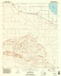
1992 Map of Kane Spring
USGS Topo · Published 1995About this map
Kane Spring and the Elmore Desert Ranch anchor this arid landscape within the Imperial Valley, where the harsh desert meets complex irrigation engineering. The northern edge of the map is dominated by the Salton Sea, recorded at 228 feet below sea level. This topography highlights the extreme nature of the California basin, where San Felipe Creek winds toward the salt-laden sink.
Find a feature on this map
15 named features on this map. Tap any name to fly to it.
Don’t see what you’re looking for? This feature index may not catch every label — zoom into the map to look around manually.
Map Details
Editions of this 1992 Kane Spring Map
This is the sole edition of this map. No revisions or reprints were ever made.
Other maps of this area

1915 · El Centro
USGS Topo · 1:125,000

1940 · Brawley
USGS Topo · 1:62,500

1940 · Kane Spring
USGS Topo · 1:62,500

1940 · Plaster City
USGS Topo · 1:62,500

1942 · El Centro
USGS Topo · 1:250,000

1943 · Brawley
USGS Topo · 1:62,500

1944 · Plaster City
USGS Topo · 1:62,500

1944 · Kane Spring
USGS Topo · 1:62,500

1944 · Calipatria
USGS Topo · 1:62,500

1954 · El Centro
USGS Topo · 1:250,000