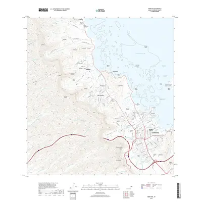
2017 Map of Kaneohe
USGS Topo · Published 2017About this map
The windward coast of O'ahu is defined by the dramatic meeting of the Ko'olau Range and the waters of Kāne'ohe Bay. This modern survey details the dense suburban development of Kaneohe and neighboring Heeia, where complex road networks navigate the transition from sea level to the steep mountain ridges. Ancient and modern land uses sit side-by-side, from the Kahalu'u Pond and Kanohuluwi Fish Pond to the sprawling grounds of the Valley of the Temples. Significant civil and military infrastructure is evident, including the Kaneohe Bay Marine Corps Air Station at the bay's edge and several major transit corridors like the Wilson Tunnel and Luluku Tunnel that pierce the volcanic ridges. Smaller settlements like Waikāne and Kahaluu anchor the northern shoreline, connected by the coastal highway to the memorial sites at Hawaiian Memorial Park.
Find a feature on this map
171 named features on this map. Tap any name to fly to it.
Don’t see what you’re looking for? This feature index may not catch every label — zoom into the map to look around manually.
Map Details
Editions of this 2017 Kaneohe Map
This is the sole edition of this map. No revisions or reprints were ever made.
Other maps of this area

1952 · Koko Head
USGS Topo · 1:24,000

1952 · Mokapu
USGS Topo · 1:24,000

1953 · Honolulu
USGS Topo · 1:24,000

1953 · Puuloa
USGS Topo · 1:24,000

1953 · Hauula
USGS Topo · 1:24,000

1954 · Oahu
USGS Topo · 1:250,000

1954 · Kahana
USGS Topo · 1:24,000

1954 · Kaneohe
USGS Topo · 1:24,000

1954 · Waipahu
USGS Topo · 1:24,000

1959 · Mokapu
USGS Topo · 1:24,000