
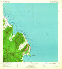
1954 Map of Kahana
USGS Topo · Published 1955About this map
Kaawa and the windward coast of Oahu are depicted here during the mid-1950s, a period defined by small settlements clinging to the narrow coastal strip between the Pacific and the steep mountains. Evidence of the island's agricultural history is preserved in the Sugar Mill (Ruin) and its nearby chimney just north of Molii Pond. Large fishponds like Huila Pond and Fishpond along the shoreline illustrate traditional Hawaiian coastal management alongside the developing Kamehameha Highway.
Find a feature on this map
47 named features on this map. Tap any name to fly to it.
Don’t see what you’re looking for? This feature index may not catch every label — zoom into the map to look around manually.
Map Details
Editions of this 1954 Kahana Map
2 editions found
Other maps of this area

1952 · Mokapu
USGS Topo · 1:24,000

1953 · Hauula
USGS Topo · 1:24,000

1954 · Oahu
USGS Topo · 1:250,000

1954 · Kahuku
USGS Topo · 1:24,000

1954 · Kaneohe
USGS Topo · 1:24,000

1954 · Waipahu
USGS Topo · 1:24,000

1959 · Mokapu
USGS Topo · 1:24,000

1959 · Kaneohe
USGS Topo · 1:24,000

1959 · Waipahu
USGS Topo · 1:24,000

1961 · Oahu
USGS Topo · 1:250,000