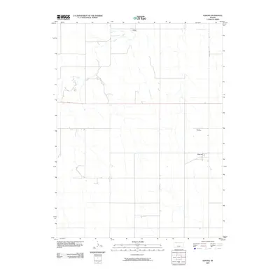
2009 Map of Kanona
USGS Topo · Published 2009About this map
Kanona serves as the quiet anchor of this Decatur County landscape, a rural settlement defined by its grid of country roads and the winding paths of local waterways. The topography is shaped by the drainage patterns of Sappa Creek, which meanders through the northwest, and Cotton Creek, flowing southward across the central plains. Just north of the town center, Kanona Cemetery stands as a primary point of interest for genealogists and local historians, marking the legacy of the area's early farming families. The map illustrates a high-plains environment where transportation remains tied to the sectional grid, including Co RD 495 and Co RD 491, while Route 36 provides the main east-west artery through this agricultural region. Notable natural features like Rock Draw further distinguish the subtle relief of the High Plains terrain.
Find a feature on this map
8 named features on this map. Tap any name to fly to it.
Don’t see what you’re looking for? This feature index may not catch every label — zoom into the map to look around manually.
Map Details
Editions of this 2009 Kanona Map
This is the sole edition of this map. No revisions or reprints were ever made.
Other maps of this area

1951 · Selden
USGS Topo · 1:62,500

1951 · Oberlin
USGS Topo · 1:62,500

1951 · Kanona
USGS Topo · 1:62,500

1954 · Goodland
USGS Topo · 1:250,000

1956 · Goodland
USGS Topo · 1:250,000

1957 · Goodland
USGS Topo · 1:250,000

1965 · Kanona SE
USGS Topo · 1:24,000

1965 · Oberlin
USGS Topo · 1:24,000

1965 · Kanona
USGS Topo · 1:24,000
1965 · Kanona NW
USGS Topo · 1:24,000