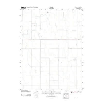
2012 Map of Kanona
USGS Topo · Published 2012About this map
Kanona serves as the focal point for this Decatur County landscape, a rural settlement defined by its connection to the surrounding agricultural plains. The topography is shaped by the gentle drainages of Sappa Cr and Cotton Cr, which cut through the terrain alongside other natural features like Rock Draw. This 2012 survey illustrates the grid-based road system typical of the High Plains, where local routes such as Co RD 491 and Co RD 495 provide the primary infrastructure for the dispersed farmsteads of the region. Genealogists and local historians will find the Kanona Cem north of the main settlement, a primary landmark for tracing the families who established this community in western Kansas.
Find a feature on this map
7 named features on this map. Tap any name to fly to it.
Don’t see what you’re looking for? This feature index may not catch every label — zoom into the map to look around manually.
Map Details
Editions of this 2012 Kanona Map
This is the sole edition of this map. No revisions or reprints were ever made.
Other maps of this area

1951 · Selden
USGS Topo · 1:62,500

1951 · Oberlin
USGS Topo · 1:62,500

1951 · Kanona
USGS Topo · 1:62,500

1954 · Goodland
USGS Topo · 1:250,000

1956 · Goodland
USGS Topo · 1:250,000

1957 · Goodland
USGS Topo · 1:250,000

1965 · Kanona SE
USGS Topo · 1:24,000

1965 · Oberlin
USGS Topo · 1:24,000

1965 · Kanona
USGS Topo · 1:24,000
1965 · Kanona NW
USGS Topo · 1:24,000