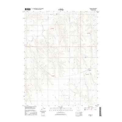
2015 Map of Kanona
USGS Topo · Published 2015About this map
Kanona serves as the focal point of this western Kansas landscape, situated in an area defined by the steady incision of prairie waterways. The settlement is positioned near the junction of several county roads, including Co RD 495 and Q LN, reflecting the geometric precision of the Public Land Survey System that governs the regional layout. The surrounding terrain is shaped by the drainage of Sappa Cr and Cotton Cr, which carve shallow valleys through the high plains. A few miles northwest of the town site, Rock Draw provides a distinct topographic break in the otherwise consistent elevation of the quadrangle. For those researching local heritage, the Kanona Cem north of the primary settlement offers a specific point of interest for genealogical study within this Decatur County township.
Find a feature on this map
20 named features on this map. Tap any name to fly to it.
Don’t see what you’re looking for? This feature index may not catch every label — zoom into the map to look around manually.
Map Details
Editions of this 2015 Kanona Map
This is the sole edition of this map. No revisions or reprints were ever made.
Other maps of this area

1951 · Selden
USGS Topo · 1:62,500

1951 · Oberlin
USGS Topo · 1:62,500

1951 · Kanona
USGS Topo · 1:62,500

1954 · Goodland
USGS Topo · 1:250,000

1956 · Goodland
USGS Topo · 1:250,000

1957 · Goodland
USGS Topo · 1:250,000

1965 · Kanona SE
USGS Topo · 1:24,000

1965 · Oberlin
USGS Topo · 1:24,000

1965 · Kanona
USGS Topo · 1:24,000
1965 · Kanona NW
USGS Topo · 1:24,000