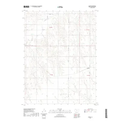
2018 Map of Kanona
USGS Topo · Published 2018About this map
Kanona serves as the primary focal point of this Decatur County landscape, situated where the high plains are dissected by several significant drainage systems. The hydrology of the region is defined by the winding course of Sappa Cr in the northwest and Cotton Cr further east, alongside the prominent Rock Draw. These waterways have carved a rhythmic pattern of ridges and draws into the terrain, influencing the placement of the local transportation network.
Find a feature on this map
21 named features on this map. Tap any name to fly to it.
Don’t see what you’re looking for? This feature index may not catch every label — zoom into the map to look around manually.
Map Details
Editions of this 2018 Kanona Map
This is the sole edition of this map. No revisions or reprints were ever made.
Other maps of this area

1951 · Selden
USGS Topo · 1:62,500

1951 · Oberlin
USGS Topo · 1:62,500

1951 · Kanona
USGS Topo · 1:62,500

1954 · Goodland
USGS Topo · 1:250,000

1956 · Goodland
USGS Topo · 1:250,000

1957 · Goodland
USGS Topo · 1:250,000

1965 · Kanona SE
USGS Topo · 1:24,000

1965 · Oberlin
USGS Topo · 1:24,000

1965 · Kanona
USGS Topo · 1:24,000
1965 · Kanona NW
USGS Topo · 1:24,000