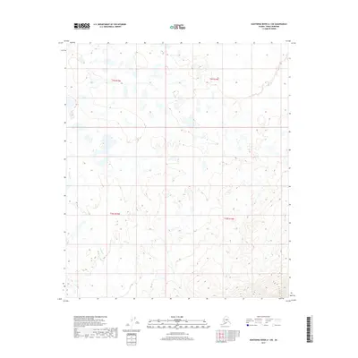
2017 Map of Kantishna River A-1 SW
USGS Topo · Published 2017About this map
Chitsia Cr winds through this expanse of the Alaskan interior within the Denali Borough. The map reveals a transition between lowland wetlands and the rising foothills of the Alaska Range, characterized by numerous small lakes and ponds scattered across the northern sections of t9s r15w and t9s r14w. To the south, the topography shifts noticeably in t10s r15w and t10s r14w, where the contour lines tighten, indicating the beginning of more significant elevation gains. This 2017 survey reflects the remote and largely undeveloped character of the Kantishna River region, where the landscape is defined by its natural hydrology and shifting drainage patterns rather than human infrastructure or settlements.
Find a feature on this map
5 named features on this map. Tap any name to fly to it.
Don’t see what you’re looking for? This feature index may not catch every label — zoom into the map to look around manually.
Map Details
Editions of this 2017 Kantishna River A-1 SW Map
This is the sole edition of this map. No revisions or reprints were ever made.
Other maps of this area

1948 · Kantishna River
USGS Topo · 1:250,000

1951 · Kantishna River
USGS Topo · 1:250,000

1951 · Mount McKinley D-1
USGS Topo · 1:63,360

1952 · Mount McKinley
USGS Topo · 1:250,000

1952 · Kantishna River A-1
USGS Topo · 1:63,360

1952 · Kantishna River
USGS Topo · 1:250,000

1952 · Kantishna River A-2
USGS Topo · 1:63,360
1953 · Kantishna River A-1
USGS Topo · 1:63,360

1954 · Mount McKinley D-2
USGS Topo · 1:63,360

1954 · Mount McKinley D-1
USGS Topo · 1:63,360