
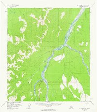
1954 Map of Mount McKinley D-1
USGS Topo · Published 1963About this map
The Mt McKinley National Park boundary defines the southern portion of this mid-century interior Alaskan landscape, where the braided channels of the Toklat River and Kantishna River dominate the drainage system. The area reflects a transient wilderness economy of the 1950s, marked by scattered cabins and a Placer Mine near Marten Creek. Transportation relies on the natural geography and seasonal routes, specifically the Winter Trail and the Stampede Landing Strip located near the Clearwater Fork.
Find a feature on this map
26 named features on this map. Tap any name to fly to it.
Don’t see what you’re looking for? This feature index may not catch every label — zoom into the map to look around manually.
Map Details
Editions of this 1954 Mount McKinley D-1 Map
2 editions found
Other maps of this area

1948 · Kantishna River
USGS Topo · 1:250,000

1950 · Fairbanks
USGS Topo · 1:250,000

1951 · Healy
USGS Topo · 1:250,000

1951 · Kantishna River
USGS Topo · 1:250,000

1951 · Fairbanks
USGS Topo · 1:250,000

1951 · Mount McKinley D-1
USGS Topo · 1:63,360

1951 · Healy D-6
USGS Topo · 1:63,360

1952 · Mount McKinley
USGS Topo · 1:250,000

1952 · Fairbanks A-6
USGS Topo · 1:63,360

1952 · Kantishna River A-1
USGS Topo · 1:63,360