
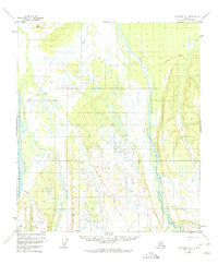
1952 Map of Fairbanks A-6
USGS Topo · Published 1957About this map
The Teklanika River and Toklat River dominate this interior landscape, marking a transition between braided river valleys and the upland terrain of the Fourth Judicial Division. Recorded during the early 1950s, the map highlights the primitive transportation networks of the era, most notably a seasonal Sled Road that traverses the northern reaches. This route, alongside the Sushana River, reflects a time when overland travel in this part of Alaska relied heavily on winter-ready trails and river corridors before the development of modern highway infrastructure. Survey markers like VABM Nika and VABM Rick provide fixed points of reference in a wilderness defined by shifting watercourses and expansive wetlands, offering a detailed look at the hydrology of the Tanana Valley watershed during the mid-century period.
Find a feature on this map
6 named features on this map. Tap any name to fly to it.
Don’t see what you’re looking for? This feature index may not catch every label — zoom into the map to look around manually.
Map Details
Editions of this 1952 Fairbanks A-6 Map
2 editions found
Other maps of this area

1948 · Kantishna River
USGS Topo · 1:250,000

1949 · Fairbanks B-5
USGS Topo · 1:63,360

1950 · Fairbanks
USGS Topo · 1:250,000

1950 · Fairbanks A-5
USGS Topo · 1:63,360

1950 · Fairbanks B-5
USGS Topo · 1:63,360

1951 · Healy
USGS Topo · 1:250,000

1951 · Kantishna River
USGS Topo · 1:250,000

1951 · Fairbanks B-5
USGS Topo · 1:63,360

1951 · Fairbanks
USGS Topo · 1:250,000

1951 · Fairbanks A-5
USGS Topo · 1:63,360