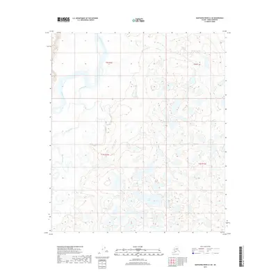
2017 Map of Kantishna River A-2 SE
USGS Topo · Published 2017About this map
The Kantishna River meanders through a low-lying interior landscape defined by water and wetlands in this 2017 survey of the Denali region. This portion of the Alaska interior is shaped by the confluence and crossing of major waterways, where the Bearpaw River joins the larger drainage system. The intricate network of seasonal ponds and established water bodies, including the Alma Lakes in the south-central portion of the map, illustrates a dynamic hydrological environment where river channels shift over time. North of these lakes, Chitsia Cr flows through the northeast, cutting across township lines that divide this wilderness. The absence of permanent roads or settlements in this particular quadrangle underscores the isolation of the Tanana Valley watershed, where the natural movement of the rivers remains the primary geographic influence.
Find a feature on this map
8 named features on this map. Tap any name to fly to it.
Don’t see what you’re looking for? This feature index may not catch every label — zoom into the map to look around manually.
Map Details
Editions of this 2017 Kantishna River A-2 SE Map
This is the sole edition of this map. No revisions or reprints were ever made.
Other maps of this area

1948 · Kantishna River
USGS Topo · 1:250,000

1951 · Kantishna River
USGS Topo · 1:250,000

1951 · Mount McKinley D-1
USGS Topo · 1:63,360

1952 · Mount McKinley
USGS Topo · 1:250,000

1952 · Kantishna River A-1
USGS Topo · 1:63,360

1952 · Kantishna River
USGS Topo · 1:250,000

1952 · Kantishna River A-2
USGS Topo · 1:63,360
1953 · Kantishna River A-1
USGS Topo · 1:63,360

1954 · Mount McKinley D-2
USGS Topo · 1:63,360

1954 · Mount McKinley D-1
USGS Topo · 1:63,360