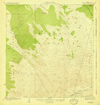
1930 Map of Kaohe
USGS Topo · Published 1930About this map
Lava Flow of 1843 and the Lava Flow of 1859 dominate this high-altitude landscape of Hawaii's Big Island, illustrating the volcanic activity that shaped the terrain within the Hamakua District and North Kona District. The survey captures a moment when the Hawaii National Park Kau District boundary reached across the cinder cones and lava fields, including the remote Volcano House and the high-elevation Mauna Loa Trail.
Find a feature on this map
20 named features on this map. Tap any name to fly to it.
Don’t see what you’re looking for? This feature index may not catch every label — zoom into the map to look around manually.
Map Details
Editions of this 1930 Kaohe Map
3 editions found
Other maps of this area

1921 · Kilauea
USGS Topo · 1:62,500

1924 · Kilauea
USGS Topo · 1:62,500

1927 · Kaohe
USGS Topo · 1:62,500

1928 · Puako
USGS Topo · 1:62,500

1928 · Kailua
USGS Topo · 1:62,500

1928 · Mauna Loa
USGS Topo · 1:62,500

1930 · Humuula
USGS Topo · 1:62,500

1930 · Kaohe
USGS Topo · 1:62,500

1954 · Hawaii South
USGS Topo · 1:250,000

1954 · Hawaii North
USGS Topo · 1:250,000