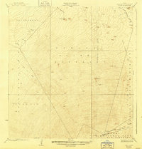
1930 Map of Kaohe
USGS Topo · Published 1943About this map
The volcanic slopes of the Hamakua District and Kona District dominate this topographic study, where the land is defined by historical eruptions. The massive Lava Flow of 1843 and Lava Flow of 1859 are clearly delineated, illustrating the stark path of molten rock across the high-elevation terrain of the Territory of Hawaii. To the south, the boundary of the Hawaii National Park Kau District encompasses the Volcano House and the Mauna Loa Trail, providing a vital record of early twentieth-century park infrastructure and exploration routes. The landscape is dotted with prominent cinder cones and pits, including Kokoolau, Puu Kogi, and Lua Ioane, alongside the distinctive Kipuka Kalawamauna, an island of older land surrounded by more recent flows.
Find a feature on this map
19 named features on this map. Tap any name to fly to it.
Don’t see what you’re looking for? This feature index may not catch every label — zoom into the map to look around manually.
Map Details
Editions of this 1930 Kaohe Map
3 editions found
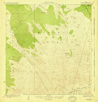
Other maps of this area

1921 · Kilauea
USGS Topo · 1:62,500

1924 · Kilauea
USGS Topo · 1:62,500

1927 · Kaohe
USGS Topo · 1:62,500

1928 · Puako
USGS Topo · 1:62,500

1928 · Kailua
USGS Topo · 1:62,500

1928 · Mauna Loa
USGS Topo · 1:62,500

1930 · Humuula
USGS Topo · 1:62,500

1930 · Kaohe
USGS Topo · 1:62,500

1954 · Hawaii South
USGS Topo · 1:250,000

1954 · Hawaii North
USGS Topo · 1:250,000