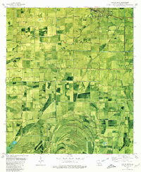
1979 Map of Kaplan South
USGS Topo · Published 1980About this map
The town of Kaplan anchors the northern reaches of this coastal Louisiana landscape, where the Southern Pacific railroad and a dense network of irrigation canals define the local economy. In the late 1970s, the region was a patchwork of agricultural fields and active energy extraction, evidenced by numerous Gas Wells scattered across the township lines. The transition toward the marshlands is marked by a series of geographic "islands"—elevated ridges like Second Island, Third Island, and Dog Island—which stand out against the surrounding low-lying terrain. Genealogy and local history are preserved in family-named cemeteries such as Marceaux Cem, Hebert Cem, and Le Maire Cem, alongside small rural settlements like Cow Island and Dubois. The presence of the Harrington Landing Field and Randall Greene Landing Strip suggests the importance of aerial access in this water-intersected parish.
Find a feature on this map
32 named features on this map. Tap any name to fly to it.
Don’t see what you’re looking for? This feature index may not catch every label — zoom into the map to look around manually.
Map Details
Editions of this 1979 Kaplan South Map
This is the sole edition of this map. No revisions or reprints were ever made.
Other maps of this area

1932 · Abbeville SW
USGS Topo · 1:31,680

1932 · Abbeville NW
USGS Topo · 1:31,680

1946 · Morse
USGS Topo · 1:31,680

1946 · Schooner Bayou SE
USGS Topo · 1:31,680

1946 · Leroy
USGS Topo · 1:31,680

1946 · Schooner Bayou NE
USGS Topo · 1:31,680

1946 · Schooner Bayou NW
USGS Topo · 1:31,680

1946 · Kaplan
USGS Topo · 1:31,680

1946 · Schooner Bayou SW
USGS Topo · 1:31,680

1952 · Lake Charles
USGS Topo · 1:250,000