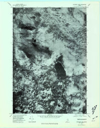
1978 Map of Katahdin Lake
USGS Topo · Published 1981About this map
Katahdin Lake dominates this orthophotographic study, which utilizes aerial imagery taken in late October to provide a direct visual record of the Maine wilderness. Unlike traditional line-drawn maps, this format uses rectified photoimagery to show the actual density of forest cover and the precise rocky outcrops of the Turner Mountain range. North Turner Mountain, East Turner Mountain, and South Turner Mountain form a massive barrier on the western side of the quadrangle, their dark slopes contrasting with the lighter, water-etched valleys. The drainage patterns of Wassataquoik Stream and Sandy Stream are clearly visible, allowing researchers to trace the exact path of these waterways through the timberlands before modern developments or changes in land management altered the forest structure.
Find a feature on this map
6 named features on this map. Tap any name to fly to it.
Don’t see what you’re looking for? This feature index may not catch every label — zoom into the map to look around manually.
Map Details
Editions of this 1978 Katahdin Lake Map
This is the sole edition of this map. No revisions or reprints were ever made.
Other maps of this area

1927 · Katahdin
USGS Topo · 1:48,000

1930 · Katahdin
USGS Topo · 1:62,500

1949 · Katahdin
USGS Topo · 1:62,500

1953 · Stacyville
USGS Topo · 1:62,500

1954 · Shin Pond
USGS Topo · 1:62,500

1954 · Presque Isle
USGS Topo · 1:250,000

1954 · Millinocket
USGS Topo · 1:250,000

1955 · Traveler Mountain
USGS Topo · 1:62,500

1958 · Presque Isle
USGS Topo · 1:250,000

1958 · Millinocket
USGS Topo · 1:250,000