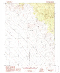
1987 Map of Kawich Peak SW
USGS Topo · Published 1988About this map
Nellis Air Force Range (Restricted Area) dominates this high-desert landscape in Nye County, showing the intersection of military operations and protected wildlands in the late twentieth century. The terrain is characterized by the slopes of the Kawich Range, where resource extraction and range management converge. Sparse but vital water sources like Tunnel Spring, Corral Spring, and a Water Trough punctuate the arid environment, serving as critical points for the Nevada Wild Horse Management Area. Evidence of mineral exploration is visible through several clusters of Prospects located in the northern reaches of the quadrangle. This provisional mapping captures a specific moment when government land use and natural resources were carefully monitored, including the presence of a Tower 54 Ft standing as a man-made landmark in the open basin.
Find a feature on this map
10 named features on this map. Tap any name to fly to it.
Don’t see what you’re looking for? This feature index may not catch every label — zoom into the map to look around manually.
Map Details
Editions of this 1987 Kawich Peak SW Map
This is the sole edition of this map. No revisions or reprints were ever made.
Other maps of this area

1908 · Kawich
USGS Topo · 1:250,000

1942 · Cactus Range
USGS Topo · 1:125,000

1942 · Reveille Peak
USGS Topo · 1:125,000

1952 · Stinking Spring
USGS Topo · 1:62,500

1952 · Mellan
USGS Topo · 1:62,500

1952 · Kawich Peak
USGS Topo · 1:62,500

1952 · Quartzite Mtn
USGS Topo · 1:62,500

1954 · Goldfield
USGS Topo · 1:250,000

1955 · Goldfield
USGS Topo · 1:250,000

1958 · Goldfield
USGS Topo · 1:250,000