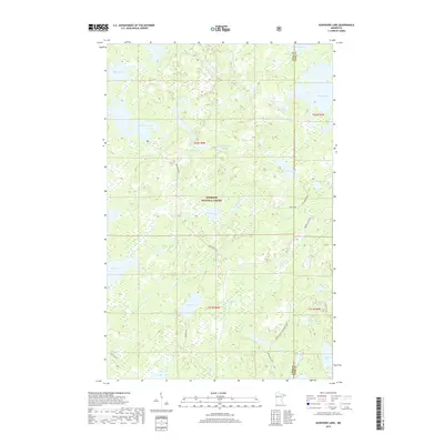
2019 Map of Kawishiwi Lake
USGS Topo · Published 2019About this map
Superior National Forest defines this vast northern landscape, where an intricate network of waterways provides the primary structure for the region. Central to this survey is Kawishiwi Lake, joined by a constellation of smaller water bodies such as Phoebe Lake, Sundown Lake, and Bill Lake. The map reveals the hydrography of the Boundary Waters area, tracing the winding paths of Hog Creek and Coffee Cr through the dense forest. While natural features dominate, several specific access points are noted, including Perent Lake Road and the Cross River/Wringer Lake route. This 2019 edition offers a contemporary look at the preservation of this wilderness area along the border of Lake and Cook Counties, highlighting the persistence of unnamed trails and primitive forest roads like Hog Creek Spur A that serve as the only terrestrial markers in the backcountry.
Find a feature on this map
33 named features on this map. Tap any name to fly to it.
Don’t see what you’re looking for? This feature index may not catch every label — zoom into the map to look around manually.
Map Details
Editions of this 2019 Kawishiwi Lake Map
This is the sole edition of this map. No revisions or reprints were ever made.
Other maps of this area

1954 · Two Harbors
USGS Topo · 1:250,000

1955 · Tofte
USGS Topo · 1:62,500

1955 · Cramer
USGS Topo · 1:62,500

1957 · Two Harbors
USGS Topo · 1:250,000

1958 · Two Harbors
USGS Topo · 1:250,000

1960 · Lake Polly
USGS Topo · 1:24,000

1960 · Kawishiwi Lake
USGS Topo · 1:24,000

1960 · Perent Lake
USGS Topo · 1:24,000

1960 · Beth Lake
USGS Topo · 1:24,000
1960 · Kelso Mountain
USGS Topo · 1:24,000