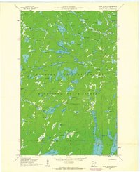
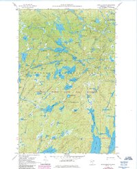
1960 Map of Kelso Mountain
USGS Topo · Published 1963About this map
Kelso Mountain and its Lookout Tower rise above a dense network of glacial lakes and waterways within the Superior National Forest. This 1960s landscape, surveyed by the Geological Survey and the Minnesota Iron Range Resources and Rehabilitation Commission, highlights a complex drainage system where the Frost River connects northern basins like Afton Lake and Intersection Lake. The map details a labyrinth of water bodies with distinctive names such as Mesaba Lake, Lawless Lake, and Myth Lake, reflecting a period when deep-water bathymetry was being integrated into topographic studies through charts from the Minnesota Department of Conservation. No roads penetrate this interior region, which is instead defined by its natural boundaries, including the Minnesota State Forest and the township lines of T. 64 N. and T. 63 N.
Find a feature on this map
80 named features on this map. Tap any name to fly to it.
Don’t see what you’re looking for? This feature index may not catch every label — zoom into the map to look around manually.
Map Details
Editions of this 1960 Kelso Mountain Map
5 editions found
Other maps of this area

1954 · Two Harbors
USGS Topo · 1:250,000

1957 · Two Harbors
USGS Topo · 1:250,000

1957 · Quetico
USGS Topo · 1:250,000

1958 · Two Harbors
USGS Topo · 1:250,000

1959 · Ogishkemuncie Lake
USGS Topo · 1:24,000

1959 · Gillis Lake
USGS Topo · 1:24,000

1960 · Lake Polly
USGS Topo · 1:24,000

1960 · Kawishiwi Lake
USGS Topo · 1:24,000

1960 · Sawbill Camp
USGS Topo · 1:24,000

1960 · Beth Lake
USGS Topo · 1:24,000